How to cover all of Estonia
According to a coverage model calibrated with the 2025 and 2026 drive tests, a 20-site network on Levira’s existing masts would reach about 96% of Estonia’s population and 84% of its land area with robust public warning.
Handset at 1.5 m, 50% of locations. Measurements were made from July to October and do not represent winter conditions.
From 5 sites to 20
The model includes the five pilot transmitters and 15 additional transmitters on Levira’s existing masts. The additional transmitters are shown on the map only through their coverage.
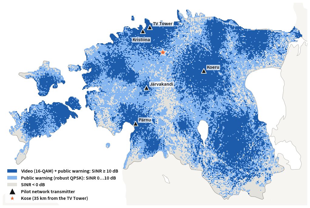
Public warning: robust QPSK
Alerts are small, and what matters most is that they get through. They can therefore be sent in the most robust QPSK mode (code rate ~1/3), which works at a signal-to-noise ratio (SINR) of 0 dB. Public warning should be planned on this layer.
TV: 16-QAM
TV and radio need a cleaner signal (SINR ≥ 10 dB). This layer is narrower and concentrated around the main masts. The 16-QAM map shows media service quality, not where public warnings reach.
The threshold matters. With a stricter QPSK threshold (SINR ≥ 3 dB), a 20-site network would cover 72% of the land area and 94% of the population with public warning. A video test with a phone at Kose, about 35 km from the TV Tower, agreed with the model.
How the model was built
Path loss is calculated from the terrain profile (ITU-R P.452, Copernicus elevation model) with a forest-cover correction. The model was calibrated with 62,206 measurement records from 2026, including 47,936 records where no signal was detected. Using the non-detections as well keeps the prediction from relying only on the strong spots, so it errs on the cautious side. An independent 2025 dataset confirmed the model.
Public warning coverage per county
Orange: 20-site network. Black: today’s pilot network (in brackets). Share of the county’s land area.
Coverage in the city
A county map does not show how buildings affect reception at street level. 3D views were therefore made for selected urban areas, showing the predicted field strength together with a 3D model of buildings and greenery.
In open areas, over water and on rooftops the field strength is mostly above 60 dBµV/m. In dense areas it drops to 30–50 dBµV/m in the shadow of buildings, most clearly in Tallinn’s Old Town and between the apartment blocks of Lasnamäe and Õismäe. The Kristiina gap filler sits exactly where the TV Tower signal is weakest in the city.
Three UHF channels
The country does not need one large single-frequency network. It works better to divide Estonia into regional clusters on three UHF channels: E40, E41 and E46.
The final frequency plan requires an impact analysis of relocating digital TV multiplexes, coordination with neighbouring countries and SFN timing calculations. The baseline is a 200 µs cyclic prefix; 300 µs will also be checked for long distances and over sea.